Energy & Wetlands Research Group, CES TE 15, Center for Ecological Sciences , New Bioscience Building, Indian Institute of Science, Bangalore 560 012, India
Corresponding author: T.V. Ramachandra
E-mail: cestvr@ces.iisc.ac.in, energy@ces.iisc.ac.in.
Citation: T.V. Ramachandra, 2014. Hydrological Responses at Regional Scale to Landscape Dynamics, J Biodiversity, 5(1,2): 11-32.
Study Area
Sharavathi river (Fig. 1) originates at Ambuteertha, near Kavaledurga in Tirthahalli taluk. It flows in a north-westerly direction and receives the Haridravathi on the right and Yenneholé on the left. Near the border of the district, it bends to the west and hurls down the ghats near Jog where it is harnessed for generating electricity. It discharges into the sea at Honnavar in Uttara Kannada (Fig. 2). Its total length is 128 km and in Shimoga district its length is 32.2 km. Figure 1 depicts the location of the study area in India and Karnataka. Sharavathi river basin falls in two districts namely Uttara Kannada and Shimoga. Upstream river basin extends to two taluks in Shimoga viz. Hosanagara and Sagara. The entire basin has an area of 2985.66 km2 with upstream and downstream respectively 1988.99 km2 and 996.67 km2 each. The basin slopes from west to east. The general elevation along the basin is about 640 m above sea level in the west. The western side of the upstream river basin rests upon the Western Ghats also known as the Sahyadri, which is a very mountainous area. The raise towards the crest of the Ghats is very rapid, a height of 1343 meters at Kodachadri according to the Survey of India. Figure 3 gives the digital elevation model of upstream. Slope percentage map derived from digital elevation model was classified into various slope groups.
Figure 4 classifies slope into 5 major slope groups.
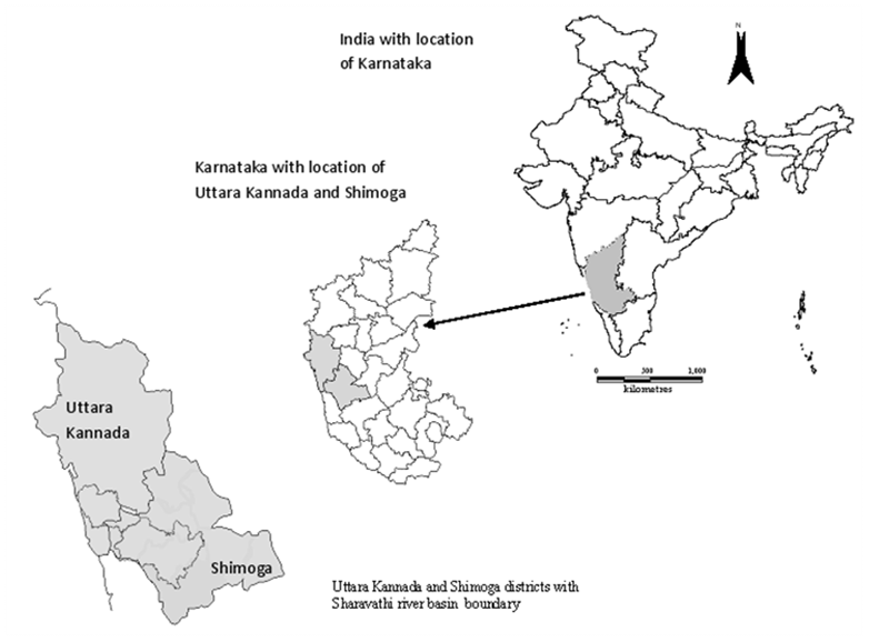
Fig. 1. Study Area – Sharavathi river basin, Karnataka state, India
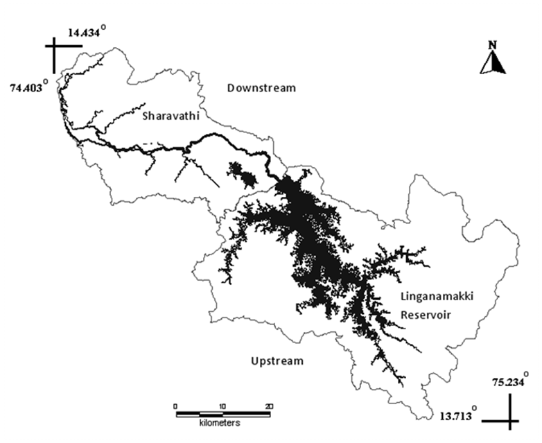
Fig. 2. Sharavathi River Basin –Upstream and Downstream
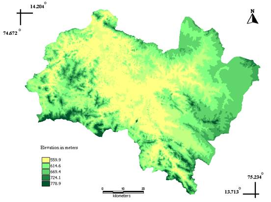
Figure 3: Digital Elevation Model – Sharavathi upstream
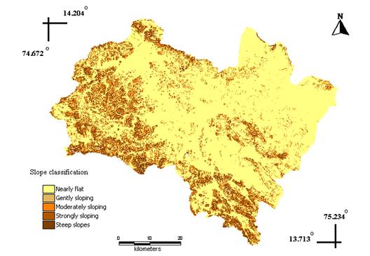
Figure 4: Slope Classification – Sharavathi upstream
Slope in percentage |
Slope group |
0-10 |
Nearly flat |
10-15 |
Gently sloping |
15-20 |
Moderately sloping |
20-30 |
Strongly sloping |
30-80 |
Steep sloping |
Table 1: Slope Classifications
This classification is given in Table 1. Steep to strongly sloping are characteristics of malnadu (mountainous region) on the western side and is covered by dense vegetation such as evergreen/semievergreen and moist deciduous forests. Slopes attain nearly level ground at the centre of the basin (reservoir) and gently slope upward towards the east. Eastern portion especially Haridravathi and Nandiholé sub basins consists of nearly level or flat land, where paddy cultivation is practiced. As can be seen from Figure 5, dense drainage network is observed in the western portion of the basin. These are areas of very steep to steep slopes. Eastern portion especially, Nandiholé and Haridravathi basins with gentle slope are characterized by less dense network. In areas of high permeability soil (such as sand) viz. in Haridravathi and Nandiholé, the drainage density is low as compared with low permeability soil (clay) and high drainage density on the western side for example Yenneholé, Hurliholé etc. Sub-basins have been delineated according to the main tributaries flowing into the reservoir as depicted in Figure 6.
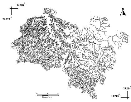
Figure 5: Drainage – Sharavathi upstream
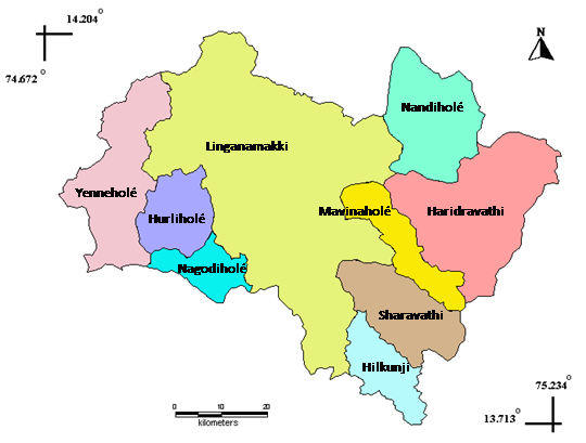
Figure 6: Sub basins of Sharavathi upstream
The climate in the study area is characterized by the monsoon regime, which superimposes itself over a regime of thermic convectional rainfall lined to the zenithal passage of the sun. The cold season is from December to February and is followed by the hot season which is from March to May. The rainfall is very heavy in the region of Western Ghats especially along the western side of the river basin. Mean annual rainfall ranges from 4500 mm in the western side to 1700 mm in the eastern side of the basin. About 95% of the rainfall is received during the south west monsoon months, June to September, July being rainiest. There is some rainfall in the post monsoon season, particularly in October, and it is mostly in the form of thundershowers. Some rainfall in the form of thundershowers also occurs during the summer months of April and May. After January, there is a rapid increase of temperatures. April is usually the hottest month with the mean daily maximum temperature at 35.8°C and the mean daily minimum at 22.2°C. The relative humidity during the mornings throughout the year generally exceeds 75%. During the monsoon months, the relative humidity in the afternoon is quite high and is ~90 %. The driest part of the year is the period from January to March when the relative humidity is less than 35%.
Evergreen to semi-evergreen forests are confined to the western part of the basin. Many of the hills are covered with heavy forests while ravines and valleys produce luxuriant trees known for their great height and size (KSG 1975). Scattered shrubs and thickets are found in the regions surrounding the reservoir. Moist deciduous forests are found in the northern and eastern part of the study area. Plantations include acacia, teak, areca, rubber, eucalyptus etc. Areca nut also called betel nut is a widely used article of consumption and is grown in valleys. Acacia plantation is found in patches, amidst evergreen forests and is mainly used for paper production. Plantation constitutes 7-9% of the total vegetation in the upstream. Evergreen /semi-evergreen and moist deciduous forests constitutes 11% and 25% respectively.
|
|
T.V Ramachandra,
Centre for Sustainable Technologies, Indian Institute of Science,
Bangalore 560 012, India.
Tel: 91-080-23600985 / 2293 3099/ 2293 2506,
Fax: 91-080-23601428 /23600085 /2360685 (CES TVR).
Web: http://ces.iisc.ac.in/energy, http://ces.iisc.ac.in/foss
|